|
| Home | Articles | Preserving Historic Charleston's Architecture |
 |
 |
|
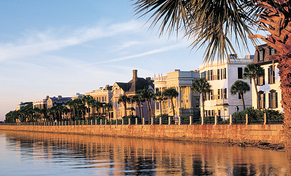
Fig. 1: The view of Charleston’s “High Battery,” the seawall along the harbor near the tip of the peninsula, from Historic Charleston Foundation’s headquarters exemplifies the architecture and urban fabric of the historic district that the foundation works to preserve. Photograph by Ron Rocz.
|
|
 |
|
|
by Winslow Hastie
|
|
 |
|
|
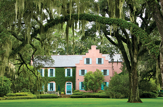
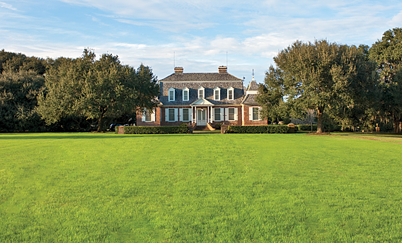
Fig. 2: The main house at Medway Plantation was constructed in circa 1704. Medway was a prosperous rice plantation located north of Charleston. HCF holds a protective easement on the building and approximately eighty acres around the house complex. This easement protects accessory buildings around the main house, including a carriage house, slave cabin, smokehouse, schoolhouse, and stables, as well as formal gardens. Photograph by the author.
|
|
|
Charleston, South Carolina, prides itself on numerous firsts. For instance, the first theater building in America was constructed in Charleston (in 1736), as was the first public golf course (in 1786). The citizens of Charleston have long been protective of their city and its unique character, and in 1931, the first historic district in the country was created by Charlestonians, and in the 1950s, the first revolving fund to purchase and rehabilitate historic buildings was developed in the city. As a result of the latter two progressive actions, Charleston represents the finest intact collection of colonial and antebellum architecture in the nation.
|
 |
|
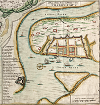
Fig. 3: One of the earliest known maps of the early fortified city, A Plan of the Town & Harbour of Charles-Town (1711), by Edward Crisp, reveals the dense settlement pattern of the city, organized in city blocks. It also shows the importance of the waterfront along the Cooper River, and how the city walls were wedged between substantial creeks to the north and the south. Library of Congress Prints and Photographs Online Catalogue.
|
Historic Charleston Foundation (HCF), founded in 1947 by a group of civic-minded leaders in the community, is a direct product of this cultural patrimony. Through its nationally-recognized preservation initiatives, including the aforementioned revolving fund, HCF has played a key role in the stewardship of Charleston’s architecture and urban fabric (Fig. 1). Its mission is to preserve and protect the historical, architectural, and cultural character of Charleston and its historic environs, as well as to educate the public about Charleston’s history and the benefits to be derived from preservation. While HCF’s efforts are typically focused on the downtown historic district, the foundation also preserves outlying properties, including significant plantations (Fig. 2).
HCF has established two major programs, the revolving fund and the easements program. The revolving fund, created by HCF around 1955, was first used to purchase endangered historic properties in Charleston’s Ansonborough neighborhood, a residential district located just north of the original walled city and which had fallen into a deteriorated state by the mid-twentieth century. The first time a preservation organization had focused on actively protecting an area of this scale, it proved very successful. Using a dedicated source of funds, HCF would purchase a dilapidated residence, stabilize the building and place restrictive covenants on the deed in order to preserve the property for the long term, then resell the property to a preservation-minded buyer. The goal was to make a small profit on each sale so that the proceeds could be rolled back into the fund—hence the term “revolving”—and the process repeated. By the end of the 1970s, over sixty Ansonborough properties had been protected; the program continues in other areas of the city today.
|
|
 |
|
|
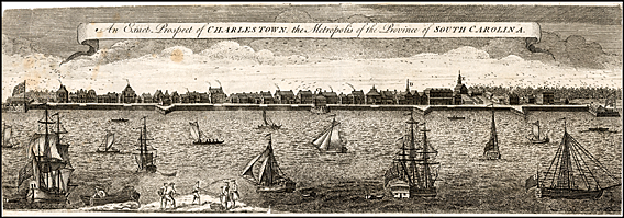
Fig. 4: Entitled An Exact Prospect of Charles-Town, the Metropolis of the Province of South Carolina (1739), this engraving by Bishop Roberts provides a rare glimpse of the buildings constructed along the waterfront before the devastating fire of 1740. With its medley of architectural forms, it could have been mistaken for a port city in England or Barbados. Library of Congress Prints and Photographs Online Catalogue.
|
|
|
The easement program is another preservation initiative that allows HCF to actively protect historic properties around Charleston. Through this process, owners of historic properties can donate preservation easements on their buildings and surrounding land to the foundation in order to protect the property in perpetuity. The easement restricts the development and use of the property (to the specifications of the owner and HCF), thereby preserving its important historic features. Preservation easements are one of the most effective tools for preserving historic properties long-term, because they allow the property to remain in private hands while the preservation organization ensures that the buildings are properly maintained and preserved for future generations. As a “co-steward” of the property, HCF works closely with the owner and provides technical guidance. The easement restrictions are attached to the deed of the property and remain even after the property is sold to subsequent owners. The foundation currently holds almost four hundred easements on properties in and around Charleston, and is a national leader in this field.
|
 |
|
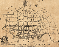
Fig. 5: Ichnography of Charleston, South-Carolina (1788), by Edmund Petrie, shows the growth of the city and the realization of the early “Grand Modell” plan, which called for an orderly grid of streets centered on a civic square, extending beyond the original city walls. This map exhibits the rapid pace of development that occurred in Charleston throughout the mid-eighteenth century. Library of Congress Prints and Photographs Online Catalogue.
|
Downtown Charleston, situated on a peninsula between the Ashley and Cooper Rivers, was established in 1680, although the original settlement upriver on the Ashley had occurred a decade earlier. As an English colonial outpost in a wild frontier populated by Indian tribes and Spanish competitors, Charleston was originally developed as a fortified city—the only English walled city in North America. The layout of the walls was determined as much by the low-lying geography of the peninsula as it was by the military fortification engineering of the period. The walled city was bracketed on its south and north sides by creeks, and its broad side faced the deepwater harbor along the Cooper River (Fig. 3). This harbor—and its waterborne access to ports in New England, the West Indies, Africa, and England—was the key to Charleston’s early success as a mercantile city.
Initial construction in the fledgling colony was quite dense, capitalizing on the valuable land along the waterfront and benefiting from shared structural walls. A 1739 view of the city from the harbor reveals that early Charleston could have been mistaken for any contemporaneous port city in England or the West Indies (Fig. 4). Many of the first settlers were opportunistic émigrés from Barbados, and while there is much scholarly debate about the level of Caribbean influence on Charleston architecture, there is no doubt that the city’s early inhabitants brought knowledge of architectural styles from both Barbados and England.
|
|
 |
|
|
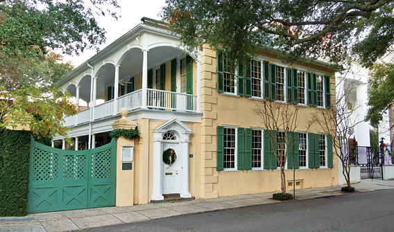
Fig. 6: The Thomas Rose House, ca. 1735, is a rare survivor of the great fire of 1740, which decimated most of the original buildings in the old walled city. This residence features its original interior layout, though the exterior was modified at the turn of the nineteenth century. Owned by a family that has played an important role in the preservation of Charleston since the formation of HCF in 1947, the preservation story of this property is quite incredible and it reveals the philanthropic spirit that permeates Charleston. The Thomas Rose House will soon be gifted to the foundation with significant exterior and interior easements to ensure that the residence and its garden are protected in perpetuity. Photography by Rick McKee; inset by Carrie Naas.
|
|
|
|
 |
|
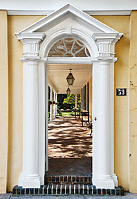
Detail of the entryway at the Thomas Rose House. Photography by Carrie Naas.
|
Once the colony was firmly established and security fears gave way to increased productivity and trade, an urban gentry of planters and merchants arose in Charleston. After various agricultural experiments with tobacco, sugar cane, and other crops, the colonists discovered that the region was particularly well suited to the production of rice. The agriculture and trade that developed around it allowed the city to prosper and grow exponentially by the early- to mid-eighteenth century.
When a devastating fire in 1740 destroyed a large portion of the walled city, much of Charleston was rebuilt. With security less of a concern and pockets brimming with newfound wealth, Charlestonians were now able to command the best in architectural design, interior finishes, decorative arts, and all the other requisite trimmings of affluence. Fashionable design trends and imported goods from across the Atlantic were influential, but more importantly, waves of artisans—carpenters, cabinetmakers, masons, and silversmiths—flooded the city, providing a high level of craftsmanship in the building and decorative arts.
An acute focus on fire safety and ventilation in the hot, humid climate prompted a move away from the earlier row house configuration, to separate, grander, high-style structures. The city had already outgrown its walled boundaries, which had been dismantled to allow for urban growth; however, the city expanded even more aggressively after the fire, fulfilling the aspirations of the early colonists (Fig. 5).
|
|
|
|
|
|
CLOCKWISE FROM LEFT:
Fig. 7: One of the earliest surviving examples of the vernacular Charleston “single house” form, the William Vanderhorst House, ca. 1740, is preserved in its original configuration with its central entry on the street. Photography by Carrie Naas.
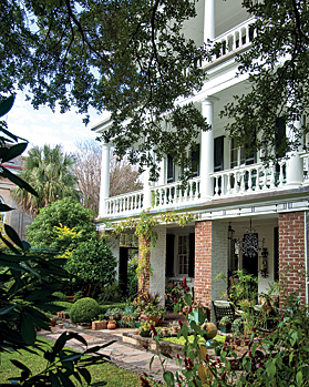
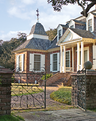
Fig. 8: The John Fullerton House, ca. 1772, a magnificent example of the Charleston single house, retains most of its Georgian exterior elements and interior finishes. The residence is accessed through the piazza to a central entry along the south elevation, which is typical of many Charleston houses. The preservation easement that HCF holds on this property protects both its exterior and interior. Photography by Rick McKee.
Fig. 9: The fine carving on this cypress mantel and overmantel in the John Fullerton House is in the second-floor drawing room, the most formal space for entertaining. Charleston was blessed with an influx of highly skilled craftspeople in the eighteenth century, all of whom contributed to the rich legacy of architecture, interior finishes, and decorative arts. Photography by Carrie Naas.
|
|
|
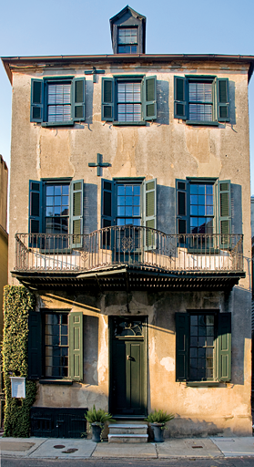
The evolution of Charleston architecture can be traced through several landmark properties. The Thomas Rose House (Fig. 6) exhibits a rare example of an asymmetrical merchant house plan. This two-story residence, built circa 1735, originally featured a central entry on the street with an office at the front where residents conducted business. (By the latter half of the eighteenth century, most businesses had migrated from residences to the commercial district along Broad and King Streets.) The second floor boasts its original full-width drawing room at the front of the house, where more formal entertaining occurred. While this was a common feature in houses of the period, it is quite rare to find such an early original floor plan still intact. As with many of the earlier Charleston residences, side piazzas, or porches, were added in the early nineteenth century, following a vernacular trend that has now become an emblematic architectural feature of the city. The piazza became the main entry into the property; it also helped to shade the south and west facades of the house from the intense southern sun, and aided in channeling the harbor breezes for ventilation.
The three-story stucco residence known as the William Vanderhorst House, circa 1740, is one of the earliest surviving examples of the iconic Charleston “single house” (Fig. 7). The single house is an architectural form that developed in Charleston to fit the typical narrow, deep lots of the early city plan, and is one room wide and typically two to three rooms deep, with the narrow end of the house facing the street. The detached accessory structures—the kitchen house, carriage house, and slave quarters—were arranged behind the main residence. This Georgian house, on which HCF holds an exterior preservation easement, features its original central entry directly on the street and never received the addition of a piazza. Most early residences, like the Thomas Rose House, lost their original street-front entry to a side entry, usually accessed through an open-air side piazza.
|
|
|
|
|
|
Figs. 10, 11: The Kohne-Leslie House, ca. 1846, is one of the finest Greek Revival residences in the Ansonborough neighborhood, and reflects the major shift in the single-house floor plan in the mid-nineteenth century. HCF purchased this house in 1958, using its innovative revolving fund, established to purchase endangered properties in the Ansonborough neighborhood of Charleston. Photography by Rick McKee.
|
|
|
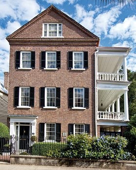
The imposing Georgian single house known as the John Fullerton House, circa 1772, retains much of its original eighteenth-century character, including its distinctive “tabernacle frame” window surrounds (Fig. 8). However, its neoclassical two-story side piazza was added around the turn of the nineteenth century. While it’s difficult to label any house in Charleston “typical,” this residence exhibits traits that are more commonly found on single houses throughout the historic district. The front door is on the side piazza, where the main entry to the house is located. Inside the house, the center hall is flanked by two main public spaces, the front parlor and the dining room. Stairs lead to the more formal second-story drawing room at the front of the house, decorated with elaborate cypress woodwork in the mantel, overmantel, cornice molding, and elsewhere (Fig. 9) The exterior of the residence and the interiors of the more ornamented rooms are protected by an easement held by HCF.
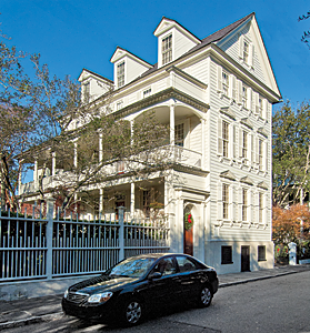
The neighborhood of Ansonborough, known as the first “suburb” of downtown Charleston, was principally developed in the early to mid-nineteenth century. The majority of the historic buildings are of brick construction because, after a fire destroyed much of the neighborhood in 1838, reconstruction loans required that buildings be constructed with fire-retardant brick, resulting in the most architecturally cohesive district in Charleston today. In 1958, HCF initiated a program called the Ansonborough Rehabilitation Project with the goal of saving this neighborhood, house by house, by purchasing and rehabilitating neighborhood residences in poor condition. This initiative galvanized the community around the crucial link between preservation and revitalization of the downtown area.
|
|
 |
|
|
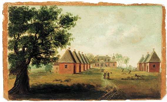
Fig. 12: Thomas Coram (American, 1756–1811)
View of Mulberry, House and Street, 1805
Oil on paper, 4-1?16 x 6-11?16 inches
Image courtesy of the Gibbes Museum of Art/Carolina Art Association, 1968.018.0001.
Mulberry Plantation, also called “Mulberry Castle” by some romantics of the nineteenth century, was built by Thomas Broughton, a planter, Indian trader, soldier, and politician from a prominent British family. The plantation was modeled after Seaton, the Broughton family estate in England. The house was designed in the Jacobean baroque style, as seen in the large windows and the small pseudo-military towers. Also distinctive to the Mulberry Plantation are the corner pavilions and gambrel roof. The brick houses lining the “street,” now destroyed, once served as slave cabins. Coram also included details of plantation life, such as figures carrying tools and animals grazing.
|
|
 |
|
|
Fig. 13: The wide lawn in front of the house is protected as an “open vista” under the easement because this was an important view shed from the front of the house towards the Cooper River. Slave cabins historically lined either side of this view shed, as seen in this Thomas Coram painting (Fig. 12). Photography by Rick McKee.
|
|
|
|
 |
|
Fig. 14: The main residence of Mulberry Plantation, circa 1712, features extremely rare corner pavilions with double-tiered, bell cast shingled roofs. Photography by Rick McKee.
|
One of the most prominent archetypal single houses in Ansonborough is the Kohne-Leslie House, circa 1846 (Fig. 10). This brick Greek Revival building replaced an earlier wood-frame residence that was destroyed in the 1838 fire. The Greek Revival period brought an innovation in the single-house floor plan that allowed for greater privacy and improved flow between the primary entertaining spaces on the main floor. Rather than entering the house from the piazza (Fig. 11), this side-hall plan features an entry directly from the street. With the stairs internalized, the side hall allowed for the circulation and reception functions to occur in a separate zone of the house; as such, the adjacent parlors on the piano nobile (the main, raised level) became more integrated since they were no longer divided by the center hall of earlier single-house floor plans, and this configuration provided unimpeded access from the parlors to the open piazza.
When HCF purchased this house in 1959, it was one of the first revolving fund properties in Ansonborough. A non-historic wood-framed building located to the south of the property was removed, restoring the garden area to its original dimensions. HCF placed restrictive covenants on this property when it was resold in 1962, and those restrictions were later converted into an interior easement and an exterior easement to protect the garden area from being subdivided or developed.
|
|
|
|
 |
|
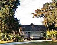
Fig. 15: HCF's easement protects the acreage and outbuildings around the main residence at Mulberry Plantation, including this restored slave cabin. The cabin, of wood-frame construction, would have housed two families. The pond behind the cabin is a former impoundment used for rice cultivation. Photography by Rick McKee.
|
Honoring its commitment to also preserve the “environs” of Charleston, HCF has several dedicated initiatives to protect the significant rural landscapes surrounding the downtown. The bulk of these efforts have focused on the plantation districts along the Ashley and Cooper River corridors, which both thread roughly northwards from the historic core of the city. In 1974, HCF was instrumental in getting the National Trust for Historic Preservation to purchase and protect Drayton Hall along the Ashley River (click here), and, today, the foundation continues to focus preservation planning efforts along this historic corridor. Along the Cooper River, the foundation also saved Mulberry Plantation, another very significant early plantation property (Figs. 12-15). The main house, constructed in circa 1712, is the oldest exposed brick residence to survive in the Carolinas or Georgia. In 1987, the property was threatened to be converted into a golf course community, with the manor house serving as the golf club. Using its Revolving Fund, HCF purchased the property and significant acreage around it, and then sold it to an appropriate buyer that is committed to its long-term stewardship.
|
|
|
Historic preservation is not just about preserving old buildings; it is also about protecting the cultural vitality and livability of a city and its picturesque surroundings. A crucial focus for HCF is to ensure that Charleston does not become an ossified museum of remarkable architecture, but rather that it grows sustainably as a living, evolving city, embracing the past for the betterment of the future.
|
|
|
|
|
|
|
Winslow Hastie is the director of Preservation & Museums at Historic Charleston Foundation, Charleston, South Carolina.
|
|
|
 Download the Complete Article in PDF Format Download the Complete Article in PDF Format Get Adobe Acrobat Reader Get Adobe Acrobat Reader
|
|
|
|
|